
What are drones
In the UK drones are described as Unmanned Aerial Vehicles (UAVs) and can be utilised for a wide range of uses from aviation, military, surveying, mapping and even Amazon deliveries.
At JCA (and our sister company bthdrones) we are particularly interested in the photo & video qualities of the drone and how we can best utilise and incorporate this into our field of architecture and the construction industry in general.
Using drones for surveys
As CAA approved commercial drone pilots we often use a drone to carry out surveys on existing properties. Due to their small size, relative ease of manoeuvrability and amazing quality photo & video capability, drones make an easy task of accessing difficult to reach places.
Instead of relying on manpower to try to reach potentially unsafe or challenging terrain, you can just send a drone in. For example, rather than sending a worker up a tenuous structure, such as a bridge, to have them photograph and record information, you can simply fly a drone up there to provide close-up footage which can be sent in real-time to the architect on the project.
Aerial photographs
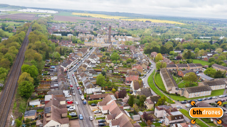
We use a DJI Mavic Pro drone which has on board a small camera capable of capturing 12 megapixel images and Ultra-HD 4k videos, the results are stunning.
The aerial photography provided by drones is extremely useful in allowing both the architect and the client to not only visualise how the finished product will look in the landscape but also to later showcase it when it has come to fruition. Utilising a drone for aerial footage aids the architect in drawing up very accurate plans, as well as subsequent footage displaying the completion of those plans in the finished structure.
We also use our drones to take aerial photographs of existing residential properties which are then used to produce 3D sketch models to provide our clients with a very quick but powerful visual representation of the proposed scheme.
In the wider world drone photography has already revolutionised the way we interact with our surroundings giving us access to and a different perspective on our natural and built environments.
Drones on the construction site
In the construction sector, the report says, drones are already providing cheap and efficient ways to map sites and track construction progress against schedule and the original design as well as inspecting structures for ongoing wear and tear representing a huge saving in costs for the industry.
They also offer an effective method of collecting three-dimensional information, integrating it with existing building information modelling (BIM) system.
Restrictions on the use of drones
It is probably fair to say that the use of drones at present does not get the best press coverage following such incidents as the disruption caused at Gatwick and Heathrow airports in early 2019 and late 2018. As a result, UK drone laws have been subject to regular changes, and plenty more tweaks could be made in the near future.
JCA (bthdrones) are fully compliant with Civil Aviation Authority (CAA) certification/”Permission for Commercial Operations” PfCO which means, as a licensed commercial operator of UAVs we are governed and regulated by the CAA.
We also hold public liability insurance for all of our UAV flight systems. Safety is at the forefront of everything that we do and a full site risk analysis is completed for each individual project before our UAVs take to the sky.
All Architecture Great and Small | The Soleful Practitioner
James Carney Architects Ltd The Studio | 116 New Rd | South Darenth | Kent | DA4 9AR
t: 01474.879381
e: studio@carneyarchitects.co.uk